


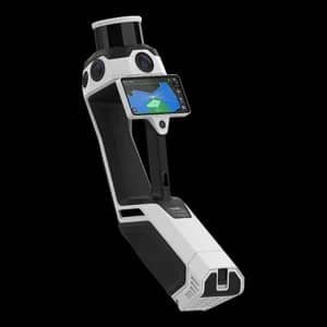
NavVis MLX Handheld Mobile Mapping Scanner
NavVisShowroomITEM'S SPECIFICS
ITEM'S DESCRIPTION
NavVis MLX is a professional portable mobile mapping system designed for fast and flexible reality capture in challenging environments. Equipped with a 32-layer LiDAR sensor and advanced SLAM technology, the system captures up to 640,000 points per second while the operator moves through the site.
The lightweight device, weighing 3.6 kg, enables efficient scanning of confined spaces, industrial facilities, construction sites, and large indoor environments where traditional scanners are less practical. Integrated panoramic imaging and high-precision point cloud generation allow for rapid creation of digital twins, BIM documentation, and facility management models.
NavVis MLX is widely used in architecture, engineering, construction, infrastructure inspection, and industrial surveying, where mobility and speed are critical.
NavVis MLX Handheld Mobile Mapping Scanner
NavVisShowroom

