

PIX4Dmatic Professional Photogrammetry Mapping Software
LeicaShowroomITEM'S SPECIFICS
ITEM'S DESCRIPTION
PIX4Dmatic is a next-generation photogrammetry software designed for professional drone mapping, surveying and large-scale reality capture projects. The software converts thousands of aerial or terrestrial images into accurate 2D maps, dense point clouds and high-quality 3D models.
Built for efficiency and performance, PIX4Dmatic can process very large datasets significantly faster than traditional photogrammetry solutions while maintaining survey-grade accuracy. The software enables professionals to handle complex mapping projects without splitting datasets or slowing down workflows.
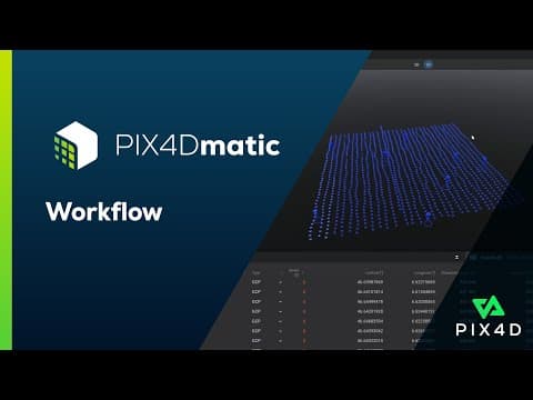
PIX4Dmatic provides a fully automated processing pipeline that allows users to import images, process them and verify project accuracy in only a few steps. The software integrates seamlessly with PIX4Dsurvey, allowing users to convert processed photogrammetry outputs into CAD-ready deliverables for engineering and surveying workflows.
The platform supports hybrid photogrammetry and LiDAR workflows, enabling users to process both RGB imagery and LiDAR data captured with devices such as PIX4Dcatch.
Key outputs generated by PIX4Dmatic include dense point clouds, orthomosaic maps, digital surface models (DSM) and textured 3D meshes.
Key capabilities include:
• high-speed photogrammetry processing for large datasets
• automated project processing workflows
• generation of dense point clouds and orthomosaics
• digital surface model (DSM) creation
• textured 3D mesh generation
• support for vertical coordinate systems and geoids
• accuracy verification using GCPs and checkpoints
• seamless export to PIX4Dsurvey for CAD vectorization
PIX4Dmatic enables surveyors, engineers and mapping professionals to quickly transform large image datasets into precise geospatial deliverables.
PIX4Dmatic Professional Photogrammetry Mapping Software
LeicaShowroom

